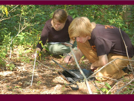
We got the new HP 2710P tablets loaded with ArcGIS software in time for the Water and Cities class. The class had more students than could fit in the GIS lab (where we have 13 seats) and the Scientific Visualization lab (22 seats) was being used. So we got into full swing and pushed the software onto all 15 tablets as quickly as we could.
We handed out the tablets and nearly immediately, one by one, students flipped the screen around and started using them to do GIS in tablet mode with the pen. I just had to snap some photos. I swear I didn't suggest it to them.
Thursday, March 27, 2008
New Tablets Used in Class

Monday, March 24, 2008
Magnetic Field and Declination in Google Earth

Thank you, Ogle Earth, for posting about the NGDC's Geomagnetism site, filled with animations, on-line calculators, tutorials and KMLs for Earth's magnetic field and declination.

This is a rich resource for teaching about geomagnetism. Here's the link to the KML.
Sunday, March 23, 2008
Video and the New Tablet PCs
The new tablet PCs for the Mobile Mapping lab come with cameras, so I felt compelled to document the un-boxing experience. I hope to make a video or two in the future with a little more substance, but in the meantime, this is the first one I've done.
Friday, March 21, 2008
Earth Album and Tibet
 I'm supposed to go to Tibet in late June with a group of Vassar professors. I don't know if our trip is going to go forward because of the recent rioting and unrest in Tibet, but I've been investigating the geography anyway.
 I stumbled upon Earth Album, a great map mash-up that bills itself as "a simpler, slicker Flickr mash-up that allows you to explore some of the most stunning photos in the world courtesy of Google maps and Flickr. " This is very true. Look at these photos of Lhasa. A ribbon of photographs pops up whenever you zoom into any area on the map.
The Panoramio photos in Google Earth give a nice picture of what's on the ground in Lhasa as well. There seem to be hundreds of photographs taken in Tibet located in Google Earth's Panoramio layer.
Whether the trip to Tibet will go as planned and whether I can handle the altitude once there are other questions, but it's nice to get a feel for the place before taking off.
Friday, March 14, 2008
Tablet PCs in Education Workshop
 There's a call for papers for a conference on the use of tablet PCs and pen-based technologies in education. I think that this is the 3rd meeting of WIPTE. Past proceedings turned into manuscripts. Though I have not attended, this conference looks promising.
"WIPTE is open to anyone with an interest in instructional technology. A wide variety of disciplines are embracing Tablet PC's and similar pen-based devices as tools for the radical enhancement of teaching and learning. This conference is intended to leverage this shared passion and to identify best practices in the educational use of pen-based computing so that all educators may benefit from this next generation of technology. Each WIPTE paper presentation includes an assessment component as an important part of the presentation. The WIPTE program also includes keynote talks, poster presentations, vendor booths, panels, and special sessions."
Call for Papers Deadline June 16, 2008
Tuesday, March 11, 2008
NERCOMP 2008: Our Talk About Assessment of Mobile Mapping
 Laptop failure be darned! My colleague in Academic Computing Services, Ginny Jones, and I gave a talk today at the annual NERCOMP meeting on our use of an assessment survey in two courses using mobile mapping. The talk was titled "Assessing student learning outcomes when using a tablet PC for data collection in field-based classes in Archaeology and Ecology" (note the truncation of the title by NERCOMP). Also note that the speaker list is out of order on the conference web site.
If you look at our slide presentation, you'll get the details, mostly pretty pictures, of what we were doing with integrating a pre-course and post-course survey in these two field-based classes.
We provided a handout of our survey results, so if you're interested in looking at those click here.

If you have any questions about our findings, thoughts on assessment, use of mobile mapping in higher education, please email me (mestewart(at)vassar(dot)edu).
What is NERCOMP, you say?
The mission of NERCOMP is to enhance the communication and dissemination of information related to the use of computers, networks and information technology in education, academic research and educational administration throughout the northeastern United States. NERCOMP is an affiliate of EDUCAUSE.
For more up-to-the-minute info on conference happenings, they're blogging the NERCOMP conference. I guess so am I!! Check out the photos shot by my other colleague, Baynard Bailey!

Tuesday, March 04, 2008
Mobile Mapping Short Course at the Geological Society of America Meeting

If you are planning on going to GSA this year (October 5-9, 2008; Houston, Texas), a couple of interesting, geospatially-significant short courses are being offered. Of particular interest is the short-course on teaching geoscience with mobile mapping (GPS, GIS, PDAs, and tablet PCs):
Teaching Field Methods in Geology Using Rugged Tablet Computers, GPS and Digital Data
Sun. 5 Oct., 8 a.m.– 5 p.m.
Mark Manone, Northern Arizona University; Peter Knoop, University of Michigan
From the GeoPad email list Feb 7, 2008: "We will be providing hardware, software and data. Let me know if anyone in this consortium would like more info or be a contributor."
Mark Manone, Geospatial Research and Information Lab (GRAIL)
Mark Manone, Geospatial Research and Information Lab (GRAIL)
In an email, Peter Knoop explains that they will be “...focusing on the use of Tablet PCs and Pocket PCs in geology and environmental sciences, with an emphasis on field settings, but we'll also touch some on best practices for using such equipment across the curricula, including in the classroom. The meeting is 5-9 October, and the short courses are usually held in the days prior the meeting."
Other geospatial short courses at GSA 2008...
Introduction to Geographic Information Systems (GIS) Using ArcGIS for Geological and Environmental Science Applications
Sat.-Sun., 4-5 Oct., 8 a.m.-5 p.m.
Ann Johnson, ESRI; Mike Price, ESRI; Willy Lynch, ESRI
The Use of GPS, LiDAR and InSAR Data to Learn About Plate Tectonics, Crustal Deformation, Isostasy and Ice Flow: A Short Course for Faculty at Two- and Four-Year Institutions
Sat. 4 Oct., 9 a.m.– 5 p.m.
Helmut Mayer, UNAVCO; Susan C. Eriksson, UNAVCO; Shelley Olds, UNAVCO
Using Authentic NASA Earth and Planetary Science Data for Inquiry in Courses for Future Science Teachers
Sat. 4 Oct., 8 a.m.– noon.
Tim Slater, University of Wyoming; Rick Pomeroy, University of California, Davis; Stephanie Shipp, Lunar Planetary Institute; Stephanie Slater, University of Wyoming; Lin Chambers, NASA
Multi- and Hyperspectral Remote Sensing for Geologic Applications
Sat. 4 Oct., 8 a.m.-5 p.m.
William Farrand, Space Science Institute; John Mars, U.S. Geological Survey
Monday, March 03, 2008
Second Life and David Rumsey

Here's a great use of the rich David Rumsey map collection. In Second Life, someone has drapped scans of some of the older maps over rendered topography for avatar investigations. See a post on it at the Not Possible IRL blog.

You can read some more at Technology Review, but you can also hear a podcast on the use of the Rumsey maps in Second Life.

I know it's not avatars in Google Earth like I've been waiting for, but it's getting closer.
Subscribe to:
Posts (Atom)


