 For the article "When Judges Make Foreign Policy" September 28, Noah Feldman.
Sunday, September 28, 2008
Nice Map on the Cover of the New York Times Magazine
Thursday, September 25, 2008
Back to Red and Blue Maps
 Who can forget the red states/blue states maps of 2000 and then 2004? Dreadful cartography, I know. But if you're trying to paint a picture of potential electoral college outcomes, this is what we have. Thank you, AnyGeo Blog, for pointing out this great site for election watchers and map aficionados. David Leip's US Election Atlas, does a great job of keeping us up-to-date on election predictions, state by state. Remember, though, that Leip likes to use blue for Republicans and red for Democrats.
Wednesday, September 24, 2008
Google Earth Games
 I like to post about geographical games when I hear about them. I heard about some more by way of TipLine. TipLine heard about the Google Earth games in Frank Taylor's Google Earth Blog. Milk Truck Madness is a favorite at home. The games with the Google Earth plugins sound great.
Wednesday, September 17, 2008
Installation Steps for ArcGIS Extensions
 One of my constituents is working on the west coast and has installed ArcGIS 9.x using the disk that I gave him. He has the ArcView license plus the 3D and Spatial Analyst extensions. However, there is a trick to making sure you get your extensions installed, and the following post is how you do it. See above for how to get started with the install.
 Next, click Install ArcGIS Desktop.
 THEN WAIT WHILE THE COMPUTER DETERMINES IF THERE'S ENOUGH AVAILABLE SPACE.
 If you have already tried to install ArcGIS plus your extensions and find that your extensions are not showing up, you will click Modify (shown above). If this is your first time with the installation process, click Custom install (not shown).
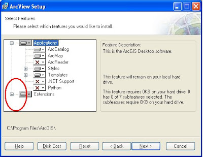
Now, the trick. Where I have circled in RED above, click on the Plus sign...
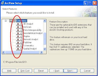
You should see a bunch of red Xs cascading under Extensions. That means those extensions are not installed.

Now, click on the drop-down arrow next to the extension(s) you wish to install, in the case above 3D Analyst and Spatial Analyst, and you will get a little hard drive icon that says "Will be installed on local hard drive." Click Next and Next and your extension installation should be successful.
You will be prompted at the end of the installation process to add your alpha-numeric license code. The the first time you launch ArcMap, go to Tools -> Extensions and then check on the extensions that you loaded (and have licenses for).
Monday, September 15, 2008
Google and Geospatial Data
 I would like to recommend the September 14 Very Spatial podcast for an informative interview with Dylan Lorimer and J.L. Needham of Google. The main topic of this interview (about ½ way into the podcast) was Google’s effort to partner with local governments for data sharing. Some of their answers were surprising to me so I thought I should share. Here are some highlights.
The data (imagery, elevation, transportation, etc.) that Google uses for Google Earth, Google Maps and Maps for Mobile are collected from every county in the U.S and are provided on hard media, or hard drive delivery. Of course, that kind of coverage is not nearly as comprehensive internationally, but Google is always working on it and has representatives all over the globe trying to establish partnerships for data sharing.
Google has, since it launched Google Earth and Google Maps, been rather secretive about their data, how it is gathered, who provides it, projection information, and so on. But in the last six months Google has been working on establishing a “front door” for open access for data sharing at: gisdata (at) google (dot) com.
Lorimer and Needham were enthused by the recent ESRI Users Conference and met with many jurisdictions and have become more open to inquiries and offerings of a variety of data types. Of course the standard data desired are aerial imagery, they also seek 3D models (textured or not), terrain data, elevation models and transit system data.
Google is not in need of U.S. baseline data but do seem to seek parcel data, address points and routing data. Lorimer and Needham were clear that local data sources, local governmental agencies, are the authority of the data and they trust the integrity of the data from these jurisdictions. Google has a program called “Cities in 3D” to reach out to local jurisdictions for their localized geospatial data.
To assess where to provide the most up-to-date and complete data, Google maintains heat maps of where their users are and where they are looking in Google Earth and Google Maps.
About the public versus private partnerships and the question that some might ask “why should I pay for the GIS group when it’s already available in Google?,” Lorimer and Needham had three points to make. 1) Google attributes the source jurisdiction of any given data set, 2) they blog about any partnership they’ve assembled and promote how-to information on the web, and 3) Lorimer and Needham said we “engage with law makers who ask uninformed questions like ‘why do we fund our GIS office or agency when all these maps are free on Google Earth?’ We help them understand that it’s because of that funding, because of that public investment, that places like Google Earth and many others are available to the public.”
Google is trying to utilize the tremendous public investment in geospatial data and get that magnified. To bring those data out of the small circle of people who use the data and provide it for everyone. They feel this is transformational.
Google is working on a self-service approach to data sharing. So a person in a jurisdiction could upload updated imagery, for example, to a web site. In the next couple of months, Google will make it more clear and streamlined as to how to share geospatial data that Google is looking for, but for now, it seems that one should go to gisdata (at) google (dot) com.
To hear the whole Very Spatial podcast:
Click to directly download MP3
Click to directly download AAC
Or go to Very Spatial.
Thursday, September 11, 2008
Buy "Mapping Our World" and Get ArcGIS 9.3 for a Year
 From ESRI Press, Mapping Our World Using GIS, by Palmer, Palmer, Malone, and Voigt, comes with a one-year license for ArcGIS 9.3. Here's a link to Amazon.
Thank you Asheville-Buncombe Technical CC.
Wednesday, September 10, 2008
Fall Semester, ArcGIS and Vista
 For our Fall classes, we did not upgrade to ArcGIS 9.3 ® and we did not upgrade to Microsoft Windows ® Vista TM and we especially did not go for a new Macintosh lab with a Parallels or a Boot Camp, or whatever. The new copies of ArcGIS 9.3 landed on my desk right as I was leaving for my summer hiatus, so it did not get burned onto our new machines in the GIS lab or Scientific Visualization lab. We did get very souped up new machines in both of these lab, however, all of the specs I don't have at hand. Not that there are problems with ArcGIS 9.3 and Vista, we're just not 100 percent confident to make the switch. I see there is already a planned-for-November service pack for the new ArcGIS 9.3. Perhaps we'll wait until Spring to upgrade to 9.3.
Friday, September 05, 2008
More Hurricane Tracking - In Google Earth
 If you're interested in following the hurricanes during hurricane season, Google Earth has added a layer in their Weather category that makes it easy. I read about this in the Lat/Long Blog when Hurricane Gustav was threatening.
Under Layers -> Weather -> Hurricane Season 2008, you'll get the latest, active hurricanes. This information was also courtesy of the Lat/Long blog.
Monday, September 01, 2008
Tracking Hurricane Gustav With Stormpulse Web Map
 If you want to follow in nearly real-time Hurricane Gustav as it approaches land (New Orleans), check out Stormpulse. They are showing category, projected track, wind speed, zooming function, among other features. This Stormpulse tracks all hurricanes, so stay posted.
Thanks Diana and All Points Blog.
Subscribe to:
Posts (Atom)


