 From ESRI Press, Mapping Our World Using GIS, by Palmer, Palmer, Malone, and Voigt, comes with a one-year license for ArcGIS 9.3. Here's a link to Amazon.
Thank you Asheville-Buncombe Technical CC.
From ESRI Press, Mapping Our World Using GIS, by Palmer, Palmer, Malone, and Voigt, comes with a one-year license for ArcGIS 9.3. Here's a link to Amazon.
 For our Fall classes, we did not upgrade to ArcGIS 9.3 ® and we did not upgrade to Microsoft Windows ® Vista TM and we especially did not go for a new Macintosh lab with a Parallels or a Boot Camp, or whatever. The new copies of ArcGIS 9.3 landed on my desk right as I was leaving for my summer hiatus, so it did not get burned onto our new machines in the GIS lab or Scientific Visualization lab. We did get very souped up new machines in both of these lab, however, all of the specs I don't have at hand. Not that there are problems with ArcGIS 9.3 and Vista, we're just not 100 percent confident to make the switch. I see there is already a planned-for-November service pack for the new ArcGIS 9.3. Perhaps we'll wait until Spring to upgrade to 9.3.
 If you're interested in following the hurricanes during hurricane season, Google Earth has added a layer in their Weather category that makes it easy. I read about this in the Lat/Long Blog when Hurricane Gustav was threatening.

Under Layers -> Weather -> Hurricane Season 2008, you'll get the latest, active hurricanes. This information was also courtesy of the Lat/Long blog.
 If you want to follow in nearly real-time Hurricane Gustav as it approaches land (New Orleans), check out Stormpulse. They are showing category, projected track, wind speed, zooming function, among other features. This Stormpulse tracks all hurricanes, so stay posted.
Thanks Diana and All Points Blog.
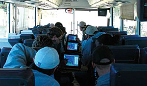 ESRI's Summer edition of ArcNews contains an article on the Purdue University soils classes that are utilizing tablet PCs and GIS software to map soils and landscapes. This program was mentioned here before and is another great example of how to use tablet PCs for field-based classes.
 From the Centre for Advanced Spatial Analysis blog, a discussion of CASA'a exploration of the worlds of Neogeography, Web 2.0 and Second Life.
Here is a copy of CASA's working paper on the subject, "The Renaissance of Geographic Information: Neogegraphy, Gaming and Second Life: Working Paper 142."
 I heard this on NPR's All Things Considered tonight. A new study looks at how cows align their bodies while resting. The researchers claim that the cows invariably align with their spines pointing north-south, like pieces of magnetite in a cooling basalt flow! The best part of this study is that the researchers used Google Earth to map the cows. Hurray for low cost research projects.
Says Richard Holland, a biologist with the University of Leeds in the United Kingdom, "It's a very clever use of Google Earth, and the evidence is quite compelling. It does seem that these animals are detecting the Earth's magnetic field and using it to point in a north-south direction."
Google's Lat Long blog has something to say about this research too.
 Here's a site where we can get digital geological maps of the whole world, OneGeology.
OneGeology's aim is to create dynamic digital geological map data for the world. It is an international initiative of the geological surveys of the world who are working together to achieve this ambitious and exciting venture.
Like a previous post mentioning touchtable technology for teaching and learning with geography, I saw a couple more options for visualizing geographic data and Google Earth in a touch-screen environment. And it's NOT a SmartBoard. Thank you, TipLine, for posting this. Perceptive Pixel has a very nice video showing their product with Google Earth, 3D modelling, and even some GIS software. Notice when the user zooms in, that the geospatial data get more detailed.
And Very Spatial had a post about the Holographic Google Earth device, that looks pretty fun.
 Great site for looking at the rapid growth of Wal-Mart in the lower 48 states. Here's a data source for Wal-Mart store openings, if you're interested.
Thanks, Diana Sinton.
 I haven't posted anything here in awhile, partly because I have the summer off. I just came back from a fantastic trip to China visiting Tibet, Chengdu, Xining, and Beijing and tried my hand at a geolocated travel blog. So with a tablet PC with a GPS receiver attached, and in-room internet access most every night, I was able to keep up with writing about the trip and keep track of where we'd been using Google Earth. I'm posting about it here because of the Google Earth placemarks that I created during the trip.
Here's the link to the travel blog.





