Thursday, April 24, 2008

Listening to Podcasts, Learning About a Multimedia Scholarly Journal

I listen to a lot of podcasts; not one of them has been relevant to this blog…until recently. I was listening to the Educause CNI (Coalition for Networked Information) podcast from the CNI 2008 Spring Task Force meeting. The featured speaker was Tara McPherson, Associate Professor of Gender Studies and Critical Studies at the University of Southern California. She is also the editor of Vectors: Journal of Culture and Technology in a Dynamic Vernacular. To get the podcast, go to iTunes and search 'Educause' and subscribe or just download this one, which is titled "Expanding the Scholarly Imagination: Vectors and Multimodal Publishing" and was put online April 22.

If you have on your campus or if you conduct work yourself that does not lend itself to traditional modes of scholarly communication, you might be interested in checking out Vectors. Billed as a "multimedia peer-reviewed journal sponsored by the Institute for Multimedia Literacy at the University of Southern California. Vectors pushes far beyond the "text with pictures" format of much online scholarly publishing, encouraging work that takes full advantage of the multimodal and networked capacities of computing technologies." This caught my attention because often times map-making in the effort to communicate something more than the map but something more than the text is what scholars want to accomplish. The communicated information and research is prone to being non-linear.

I took a look at Vectors and saw this really terrific project on Berlin. It was part of the Mobility issue of Vectors and the project is called "Hypermedia Berlin: Cultural History in the Age of New Media, or "Is There a Text in this Class?"" This project is out of UCLA, and as author Todd Presner puts it, Hypermedia Berlin is "a collaborative, multimedia, web-based research and curriculum development project, which investigates, analyzes, and maps the architectural, cultural, and historical layers of Berlin’s city space."


Here is the project page which is based in PHP, Flash and HTML. In large part, this is a mapping project using historical maps and images geo-located and then hyper-linked.

I really enjoy this Digital Humanities work, but if anyone can direct me to a geospatial podcast, I’d be much obliged.

Tuesday, April 22, 2008

Geography Game

I like geography games. There are a few out there that are a lot of fun and a great way to waste time, I mean, check your geographic knowledge and that of your children. Here's another...Chris Spagnuolo's GeoScrum.

This came my way thanks to Kenneth Kay posting a comment on this blog and then, in turn, me checking out his remote sensing/GIS blog. He posted about the GeoScrum game.

Forum Posters and Presentations - Google Earth and Tablet PCs

Last night we had another successful and fun Teaching with Technology Forum. Because this is a blog mostly related to geospatial technologies with a smattering of tablet PC references, I’ll report the posters and presentations that are those topics covered in this blog. The full list of presenters and titles are at the bottom.

The keynote address was given by Professor David Jemiolo (above) and was titled “The Dog the Didn’t Bark: Google Earth in Forensics.” Dave talked about his use of Google Earth in a forensics class and how he has the students take a Sherlock Holmes story and investigate where things might have occurs (murder, burial, and so on) based on a description in the text and place names. He also showed some of the nice images from his poster last year on taking the squash team to Barbados over spring break but how he took the student athletes to Barbados virtually prior to the trip using Google Earth.

Alan Marco of the Economics department


David Bradley of the Physics and Astronomy department

There were two tablet PC posters (above). Professors Alan Marco (Economics) and David Bradley (Physics) are using tablets in their teaching. Both are using them in lectures and for professional presentations and both came to using tablets without any influence from me. As one can imagine, I’m happy to see more and more professors taking to using tablets, especially when I don’t have to beat the drum.


And finally, Professor My Lien Nguyen (above) of Environmental Studies, Biology, and Anthropology gave a poster on her class called Ethnic Markets Research. Her students have each chosen an ethnic market in Poughkeepsie. They take a GPS receiver and get a waypoint for the market. They interview the market owner and they collect (buy) vegetables, fruits and spices from the markets. Before going out, they mapped the ethnic census data using ArcGIS then imported these maps into Google Earth. Logging each specimen, they use Flickr, Google Earth and BPwiki. I shared My Lien’s Flickr instructions previously. It was a great example of a Web 2.0 project that has meaning and relevance for the students and for the community. One of the goals for this project/class is to give back to the community a way to identify the various ethnic food sources in Poughkeepsie by using Wikipedia.

Here are all the posters:

Alan Marco, "A Tablet PC for Teaching in the Classroom

My Lien Nguyen, "Documenting Ethnic Markets in Poughkeepsie using Google
Earth, GPS mapping, and wiki-technology"

Sarita Gregory and David Esteban, "Use of Wikis to Encourage Collaboration
and Discussion"

Peter McCulloch, "Interactivity in Performance"

Jodi Schwarz and Marc Smith, "Bioinformatics: ACTG meets 01"

Meg Ronsheim and Keri VanCamp, "Environmental Studies/Vassar Farm Kiosk
Production"

Denise Walen, "My Second Life in Art: Virtual Theater and Performance"

Kathy Kurosman and Barbara Durniak, "Video Tutorials to Illustrate Library
Services"

David Bradley, "A Holistic Approach to Teaching with Technology"

Nick DeLeeuw, "Incorporating Student Blogging into Coursework"

Noelle Giuffrida, "Building Luna Insight Collections for Teaching Chinese
Visual Culture"

Jill Schneiderman, "Curating Video Clips for Classroom Instruction"

David Birn, "Sound Design for the Theatre"

Geoff Jehle, "Moodle: Open-Source Software for Collaborative Learning"

Wednesday, April 16, 2008

New, Cool Stuff with Google Earth 4.3

Don't you want to know what your hometown looks like at different times of the day and night? The above is lovely Poughkeepsie New York at 6:11 am (about six hours from now), with the view to the north, note the stars in the morning sky, and the sun angle on the low hills, thanks to Google Earth 4.3.

There are many new things to check out on this latest version. To get started, check out this video explaining some of the features.


Or go to the Google Earth Blog, which has some nice screen shots.


The navigation controls are different. The feeling is even more game-like. Looks like I have to start to play around with Google Earth again so I don't get rusty.

Oh, and you can/should download the latest version from Google Earth. My 'check for updates' didn't get me the latest and greatest and neither did my Google Updater. Just go to the source.

Tuesday, April 08, 2008

A Little Geography with Your Morning Newspaper


Announced on the Google Lat Long blog, the New York Times is providing geo-located articles that will be updated every fifteen minutes.


Look under the Gallery layer and check on the New York Times layer (shown circled in red above.)

Thanks Ogle Earth. This makes me happy. I love the Times.

Sunday, April 06, 2008

Photographs in Google Earth Using Flickr

Visiting Professor My Lien Nguyen is teaching a class called Ethnic Markets Research this semester. The students are going to local non-traditional market in Poughkeepsie and documenting the fruits and vegetables that they find. Part of that documentation includes taking photographs and part of it is identifying where the market is on a map. Welcome to Flickr and Google Earth, students! Professor Nguyen wrote the following tutorial on how to upload, name, tag, and place your Flickr photographs into Google Earth. With her permission I am sharing her tutorial. One note from the professor: the actual data and information on the plants or market sites are under-construction, and in particular, the plant photos shown have not yet been named.

Want to learn more about Flickr? Go to Educause Learning Initiative’s Seven Things You Should Know about Flickr page. Or ELI's page on Google Earth, too, which might be a little out of date.

How-To Geotag in Flickr for Viewing Photos in Google Earth

1) You need to open a Flickr account. http://www.flickr.com

2) You can name all of your photos before uploading them to Flickr – You can add in the description the scientific name.

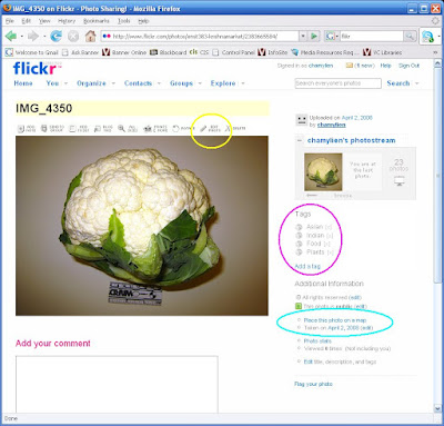
3) Upload all the photos at the same time. You will be given the option to place “Tags.” These are key words people use to surf the internet. I wrote “Asian Indian Food Plants.” All these words show up separately as tags. See the pink circle below.

4) Pictures can be edited inside Flickr - follow the links inside Flickr. I chose “Auto-fix” to brighten up some of my dark photos. I also rotated and cropped some. See the yellow circle below.

5) You can put all of your images on the map! In Flickr - click on any photo to get into edit mode. On the right lower side is: Place this photo on a map. See light blue circle below.


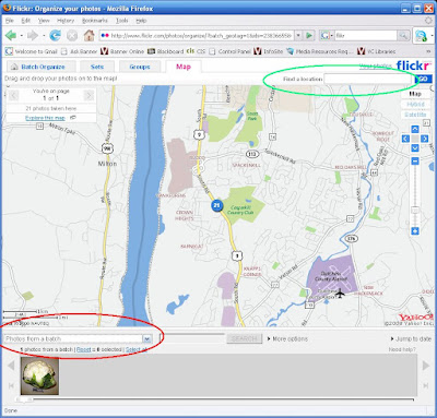
You get this:
Looking at the screen shot below, see above the photo - drop the menu (the down arrow) and select “All your photos" circled in red below. Type in the address in “Find a location” at the top of the page (See the light green circle below).


I switched to Satellite because I am used to Google Earth views. See below:


Select all and drag the photos onto the map where you want them dropped.
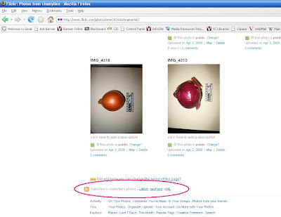
They are now geotagged! Now for each photo, there will be location information. Downside - there is a bug in the Yahoo maps that sometimes gets the wrong city name. The geotag will be correct. Upside - It gets better. Go back to Your photos page. At the bottom is an option to have “Subscribe to YourNameHere’s photos". Click on the “KML” (see the pink circle below).

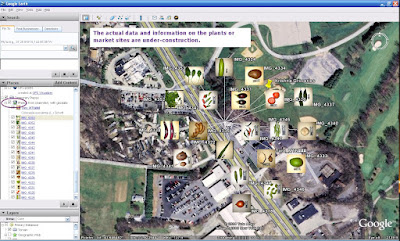
YES, KML! This puts all of your photos into a KML file that opens up in Google Earth, right where your market is! It might take time for the photos to load in Google Earth, but if you expand the KML folder (click the PLUS sign next to the KML), you will see all of your photos! Only one image will show on the map because they are all in the same location, click on that photo in the map and it will fan out all the images as shown below!


Click on an image on the map or the Places side bar, the photo descriptions will show. Go to properties and the geo-data will show. OK - we got around Panoramio! And yes, add that KML to your market page!

Remember: the actual data and information on the plants or market sites are under-construction, and in particular, the plant photos shown have not yet been named.

Wednesday, April 02, 2008

Sixth Annual Teaching with Technology Forum - Save the Date


Of interest to educational technologists, teachers using (or interested in using) technologies in the classroom, and administrators from high school on up, Vassar College’s Academic Computing Services group will host the 6th annual Teaching With Technology Forum

Monday, April 21
4:30 – 6:30 pm
in the Aula at Ely Hall
Vassar College

Poster presentations and computer demonstrations will highlight some of Vassar's broad-ranging use of technologies in teaching. Some of these technologies include: 3D imaging, Google Earth, electronic music, wikis, blogging, video tutorials, and more. A Keynote address will feature a discussion on the use of Google Earth in a Forensics class.

All are welcome. If you are in or near Poughkeepsie, NY, please feel free to come. This event is free and open. Here’s what past Forums looked like (2007, 2006, 2005, and 2004). If you have any questions, please contact me.

"How do I get there?" Then ask for directions to the Aula at the Main Gate.

Tuesday, April 01, 2008

TIGER - Line Files From ICPSR


The ICPSR announced today that it is making TIGER Line Files available that are no longer available online from the US Census Bureau. "TIGER is an acronym for Topologically Integrated Geographic Encoding and Referencing and provides users with the appropriate data to prepare maps through geographic information system (GIS) software packages."

Get your line files here. I don't know if you need a password or if access is IP-related. I got right in and downloaded a county.