Environmental Sciences in the Field -
Exploring the Impacts of Katrina GIS Exercise
A good way to understand the effects of flooding after Hurricane Katrina is to map data such as land surface elevation, demographic information, and location of important infrastructure, such as hospitals and schools. In today's exercise, we will ask you to choose a portion of New Orleans, map several variables, and report to the class on your assessment of the areas inside and outside of the flooded areas.
Find a partner. You will work with this person in presenting your findings, but you may choose to work side-by-side as you look at the maps. Find the ArcMap project New_Orleans_exercise.mxd, which will be located in the directory C:\classes\Louisiana. Explore the layers available to you. Some of the main layers you'll be using include the following:
We'll look at a variety of demographic variables in the census data first as a group.
Focus on Statistics for two Areas
Now we'll focus on two neighborhood areas. Pay attention to the methods we use here because you'll have to work on your own later.
To narrow our focus some, we'll examine the Lower Ninth Ward area and the Lakeview area in order to describe similarities and differences in distributions of census variables.
Select the Lower Ninth area neighborhoods: open the attribute table for the NO_neighborhoods layer (right click on the layer name > open attribute table). Select the Lower Ninth Ward, St. Claude, and Bywater (hold down the Ctrl key to select multiple records in the table).
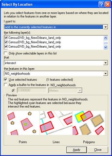
Now get the census information for those neighborhoods: go to the Selection menu > Select by Location. Check the boxes to select features from the CensusDVD layers that intersect the features in NO_neighborhoods. Make sure the Use selected features box is checked on and make sure to check all of the CensusDVD_bg_NewOrleans layers. (See figure for example.)

Now select any one of the CensusDVD layers in the map legend. Open its attribute table (right click > open attribute table).
Find the field called AVGHHINC. Right click on the field name, then click on Statistics.
Write down the Average household income for these block groups in the table below.
Now select the Lakeview, Lakewood, and West End neighborhoods in the NO_neighborhoods layer. Then repeat the selection of census data to get a mean for those three neighborhoods. Make sure you know where those neighborhoods are. Write down the average household income for this area. Now summarize five other variables by neighborhood area and add them to your data table (there are extra spaces you may not need in the table). Descriptions of the different census variables can be found in the NO_GIS_project_census_labels.csv data table.
| Variable name | Lower 9th area | Lakeview area |
| Avg household income | ||
Comment on what you learn from these comparisons:
Independent Work
Now do the same selection process for the flooded and unflooded areas: You'll select features this time by whether or not they intersect the flood layer, "Flooded area." Find 5 factors you think are important in explaining flooding effects on the city's population. Variables could include such factors as depth of flooding in different areas, distributions of hospitals and schools, and locations of transportation infrastructure, as well as the census data. With your partner, thoroughly examine your chosen factors and prepare to explain your findings to the group. Your explanation should show that you've thoughtfully contemplated the implications of the features and variables you're discussing, and you should consider relationships between your variables/features.
For your explanation, detail what you were looking at and how you carried out your analysis along with your results. Include screen captures of your maps (including legends) and paste them and your text explanations into this document. When you're finished, upload your copy to the Digital Dropbox on Blackboard. You will have the opportunity to show your word document to the class next week. We'll allot about 5 minutes per pair for the show-and-tell.


No comments:
Post a Comment