Google Earth Pro and New Orleans Data
We now have Google Earth Pro in our GIS lab. (Thank you to Google's Dennis Reinhardt and National Geographic for the grant.) The best thing about this upgrade is that we can load GIS files directly into Google Earth. Shapefiles, MapInfo files (remember those?) and GoeTIFF files are all options. You can also make movies. I want to try to do a demo on movie making for the department.
Also, if you want to use some detailed data for New Orleans immediately following Hurricane Katrina, log in as either 'Katrina - NOAA' or 'Katrina - ImageAmerica' as shown below.
Then Zoom to New Orleans.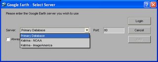
Thursday, October 19, 2006
Subscribe to:
Post Comments (Atom)


No comments:
Post a Comment