 Thanks to web tracking data, I see that there are many searches with the key words "measure" "area" and "GIS" or some variation of that theme and sometimes people stumble upon this blog. How to measure area in GIS has been a difficult undertaking, for some odd reason that I haven't yet discovered the answer.
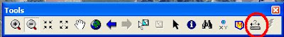
 Recently and by pure chance I found that ArcMap DOES in fact measure area very easily. Perhaps it was with ArcGIS 9.2 upgrade, but here is how you do it. I guess if you do not have the 9.2 upgrade then you need to ignore this entry because I don't believe this worked for 9.1 or earlier. As shown in the Tools toolbar above and circled in red, click on the Ruler icon which brings up the Measure tool.
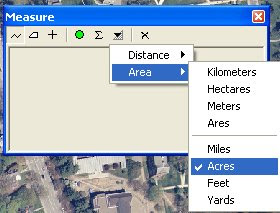
As shown above, choose your units for your Distance and for your Area.
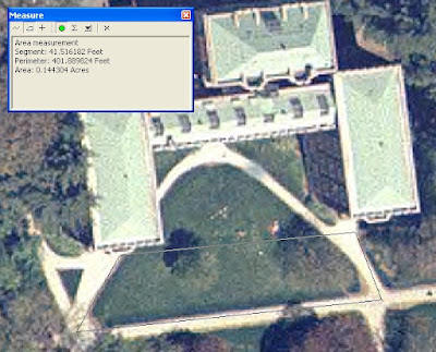
Choose the polygon icon in the Measure window and click the perimeter of the area that you are interested in measuring (shown in light gray above). You will get a linear measurement and an area, in units that you specify.
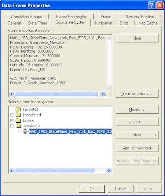
Finally, as all things ESRI, there was a little glitch when I tried this on two different data sets. I think you need to define the projection of the entire map for this to work. For instance, this technique worked beautifully with data in the above coordinate system (NY State Plane feet), but the area units were grayed out for a set of data in Geographic Coordinate System. If you figure it out, let me know because there's a world of people out there who are interested in the (easy) answer.


4 comments:
What perfect timing! I had a student yesterday who ran into the problem using the new / improved 9.2 measure tool with data in a Geographic Coordinate System. As long as all the spatial data files in your Data Frame are correctly defined as to their native coordinate system(s), you can alter the coordinate system of the Data Frame to any projected coordinate system (albeit a reasonable one for the geographic area in question). Once you have set the coordinate system of the Data Frame so that the data files are projected "on-the-fly", the area measurement tool is good to go. Then you can quickly change your Data Frame coordinate system back if you wish.
Yes, ESRI added this functionality with 9.2 but use the tool wisely. AREA and DISTANCE should never be calculated on data sets whose native spatial reference system (coordinate system / projection) is inappropriate for those characteristics. That is, area calculations on data sets kept in lat/long (Geographic Coord System, in ESRI jargon) will always be incorrect, and with this new release, ESRI has added the safety measure of not allowing the calculation to me made. Either things will be grayed out, or you'll get a warning that reminds you that you're about to do something that would generate a wrong answer (and it won't let you run it).
Area should only be calculated on data sets based on an equal area projection. Simply reprojecting the data frame "on-the-fly" to an equal area one MAY be adequate for using this tool (I haven't tested it), but it is not adequate during use of any analysis within ArcToolbox (all processes are run for the data with its inherent projection, NOT what the data frame is set to).
Diana Sinton
I am using ArcMAP 9.1 and need to get the areas of my polygons. How do I do that? Thanks for the help.
Dear Brian,
With ArcMap 9.1 we used XTools. See if it is still available for the older version of Arc (it usd to be free for a limited time)
http://www.xtoolspro.com/
and
http://gisatvassar.blogspot.com/2006/10/calculating-area-in-arcmap-why-should.html
Good luck!
Meg
Post a Comment