 Visiting Professor My Lien Nguyen is teaching a class called Ethnic Markets Research this semester. The students are going to local non-traditional market in Poughkeepsie and documenting the fruits and vegetables that they find. Part of that documentation includes taking photographs and part of it is identifying where the market is on a map. Welcome to Flickr and Google Earth, students! Professor Nguyen wrote the following tutorial on how to upload, name, tag, and place your Flickr photographs into Google Earth. With her permission I am sharing her tutorial. One note from the professor: the actual data and information on the plants or market sites are under-construction, and in particular, the plant photos shown have not yet been named.
Want to learn more about Flickr? Go to Educause Learning Initiative’s Seven Things You Should Know about Flickr page. Or ELI's page on Google Earth, too, which might be a little out of date.
1) You need to open a Flickr account. http://www.flickr.com
2) You can name all of your photos before uploading them to Flickr – You can add in the description the scientific name.
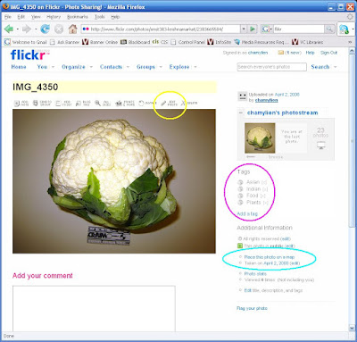
3) Upload all the photos at the same time. You will be given the option to place “Tags.” These are key words people use to surf the internet. I wrote “Asian Indian Food Plants.” All these words show up separately as tags. See the pink circle below.
4) Pictures can be edited inside Flickr - follow the links inside Flickr. I chose “Auto-fix” to brighten up some of my dark photos. I also rotated and cropped some. See the yellow circle below.
5) You can put all of your images on the map! In Flickr - click on any photo to get into edit mode. On the right lower side is: Place this photo on a map. See light blue circle below.

You get this:
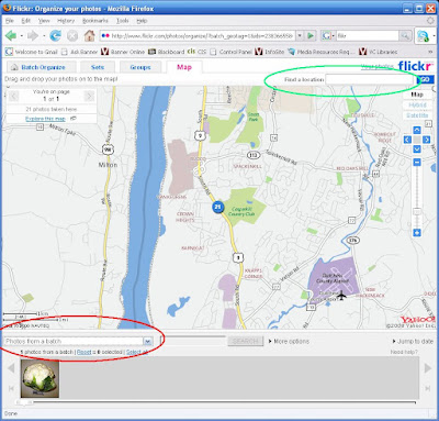
Looking at the screen shot below, see above the photo - drop the menu (the down arrow) and select “All your photos" circled in red below. Type in the address in “Find a location” at the top of the page (See the light green circle below).
 I switched to Satellite because I am used to Google Earth views. See below:
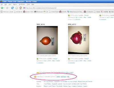
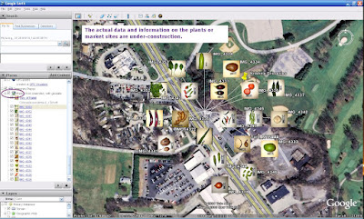
 YES, KML! This puts all of your photos into a KML file that opens up in Google Earth, right where your market is! It might take time for the photos to load in Google Earth, but if you expand the KML folder (click the PLUS sign next to the KML), you will see all of your photos! Only one image will show on the map because they are all in the same location, click on that photo in the map and it will fan out all the images as shown below!
Click on an image on the map or the Places side bar, the photo descriptions will show. Go to properties and the geo-data will show. OK - we got around Panoramio! And yes, add that KML to your market page!


3 comments:
Hi,
Good blog and useful photograph. This will really help students and GIS users.
Thanks and regards
sblgis
Sai bpo services
http://www.saibposervices.co.uk/
Hum, this is really useful, but I seem to only be able to get it to import the images on the first page of my photo stream. If I scroll back through my stream and hit KML it double imports the images from teh first page. How can you get it to import older photos?
Anonymous-I think there is a problem with Flickr in that you have a limit to the number of photos you can post to a KML. I never took the time to figure this out but the professor who worked on this project found she could import only 20 or so photos. Sorry I can't be of more help on this!
Post a Comment