More interesting mapping, this time asking the WORLD to cast a vote for either of the two major party candidates for president on the United States. The results as of this writing are stunning.
Scroll down to see the results by country, as shown below.
There was a fun map in the 10/25 New York Times Op-Art section showing the state of the states and which way they are leaning, politically. Billed as "a whimsical electoral map created by Chris Harris and Stephanie Chen," thankfully, they did not go with reds and blues. But because it is newsprint (at least how I saw it) the cartographers had to go to all those creative patterns and shadings that are better left unused. I especially liked Washington: "Fed up with the whole mess: switched over to Canada," and Alabama: "Lord I'm comin' home to you." A little whimsy is good right about now.
If you do not want your Google Earth zoom function to tilt as you zoom into a location, here is how to change the operation. This happens when you use the Plus sign on the right-side navigation tools but not when you zoom in with a mouse wheel.
Go into the Tools -> Options... menu and then click on the Navigation tab. Uncheck under Navigation Controls the box that says Automatically tilt while zooming (circled above). Google Earth 4.3 made the default setting to tilt as you zoom. Why would you want to do that?
We made a video that I'd like to share here. It has everything that this blog seems to be about, tablet PCs, mapping, instructional technology. I mentioned this video project in my last post, but I think this deserves its own post. In April we got funding from HP Philanthropy & Education to make a student-produced video documentary showing other students and professors using tablet PCs in classes. At Vassar, we teach with tablet PCs primarily in an outdoor, field-based setting. The following is the resulting video. It is 11 minutes long, so we made several shorter 'episodes' for each of the individual classes that we highlight. We hope you enjoy it.
This episode shows how Anthropology Professor Lucy Johnson uses tablet PCs in her Field Archaeology class. Professor Johnson is involved in an on-going excavation of a site at the Mohonk Preserve and her students are helping with that research. It is believed that the site was a shelter over 6,000 years ago. The students document the test pit excavations using a tablet PC and Word for drawing and writing up their observations.
In this episode, Keri VanCamp is showing how to document and map an invasive species at the Vassar Ecological Preserve. Biology Professor Robert Fritz teaches Ecology at the Preserve and his students are part of a longitudinal study of mapping the expansion of the invasive garlic mustard. The students use tablet PCs, a camera, a Word document with the various species they might encounter, and Photogrid (used for mapping ecological research sites).
And this episode shows Earth Science Professor Kirsten Menking with her Geomorphology students along Vassar's Casperkill creek, mapping the stream meanders. They are using a tablet PC, ArcGIS software and GPS receivers as well as older aerial photographs to measure the amount of stream migration over time.
And finally, this is a shorter version of the longer video. It is simply the beginning and the ending of the longer video, but we think it gives a succinct overview of how Vassar is using tablet PCs in some of our science classes.
I’m at the GSA meeting for the first time in five years. The last time I went to GSA was in 2003 in Seattle at which time I discovered tablet PCs, so this trip feels a bit like coming full circle.
First, the talk I presented. I gave a talk very similar to the one we gave and the NERCOMP meeting in March, but today's talk was titled “Taking It Outside: Using Tablet PCs to Facilitate Learning In Undergraduate Field-Based Earth Science Courses.” The slides are here and below. I also showed for the first time to a live audience our new tablet PC video. That part could have been better; I think the laptop that I used couldn't handle the .mov file. But I will link here to the YouTube site and our Vimeo site so you can see the GOOD quality videos. I think the talk went well. I felt good about the fact that little Vassar College is doing cool stuff with technology along-side the likes of UC Berkeley, Duke and Univ of Michigan.
Not shown at GSA but still something I'd like to share, is our 11-minute long documentary on tablet PC use in field-based classes at Vassar College, here in Vimeo.
Declan De Paor showed us how he uses scanned geologic and topographic maps in Google Earth in his talk called “Deconstructing Classical Geologic Maps Using Google Earth's Keyhole Markup Language.” De Paor Photoshops TM out the extraneous edge material on the maps to make the KML smaller, and he talked about using Super Overlay to reduce the size of the image files to make the KMZ a manageable size. He showed how he uses cross sections in his KMZs and then uses the timeline feauture to 'play' the relative motion. Very interesting talk by a powerhouse in geology using Google Earth and someone who I have discussed before.
Student, faculty, and researchers across the disciplines stand to benefit from adding a layer of location information to data and systems....Learning activities that formerly required taking a field trip might be accomplished through technologies that use location data to coordinate information and resources. Geolocation also provides students another avenue to contribute to the body of knowledge used by professionals in their discipline.
Who can forget the red states/blue states maps of 2000 and then 2004? Dreadful cartography, I know. But if you're trying to paint a picture of potential electoral college outcomes, this is what we have. Thank you, AnyGeo Blog, for pointing out this great site for election watchers and map aficionados. David Leip's US Election Atlas, does a great job of keeping us up-to-date on election predictions, state by state. Remember, though, that Leip likes to use blue for Republicans and red for Democrats.
I like to post about geographical games when I hear about them. I heard about some more by way of TipLine. TipLine heard about the Google Earth games in Frank Taylor's Google Earth Blog.Milk Truck Madness is a favorite at home. The games with the Google Earth plugins sound great.
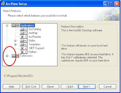
One of my constituents is working on the west coast and has installed ArcGIS 9.x using the disk that I gave him. He has the ArcView license plus the 3D and Spatial Analyst extensions. However, there is a trick to making sure you get your extensions installed, and the following post is how you do it. See above for how to get started with the install.
Next, click Install ArcGIS Desktop.
THEN WAIT WHILE THE COMPUTER DETERMINES IF THERE'S ENOUGH AVAILABLE SPACE.
If you have already tried to install ArcGIS plus your extensions and find that your extensions are not showing up, you will click Modify (shown above). If this is your first time with the installation process, click Custom install (not shown).
Now, the trick. Where I have circled in RED above, click on the Plus sign...
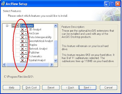
You should see a bunch of red Xs cascading under Extensions. That means those extensions are not installed.
Now, click on the drop-down arrow next to the extension(s) you wish to install, in the case above 3D Analyst and Spatial Analyst, and you will get a little hard drive icon that says "Will be installed on local hard drive." Click Next and Next and your extension installation should be successful.
You will be prompted at the end of the installation process to add your alpha-numeric license code. The the first time you launch ArcMap, go to Tools -> Extensions and then check on the extensions that you loaded (and have licenses for).
I would like to recommend the September 14 Very Spatial podcast for an informative interview with Dylan Lorimer and J.L. Needham of Google. The main topic of this interview (about ½ way into the podcast) was Google’s effort to partner with local governments for data sharing. Some of their answers were surprising to me so I thought I should share. Here are some highlights.
The data (imagery, elevation, transportation, etc.) that Google uses for Google Earth, Google Maps and Maps for Mobile are collected from every county in the U.S and are provided on hard media, or hard drive delivery. Of course, that kind of coverage is not nearly as comprehensive internationally, but Google is always working on it and has representatives all over the globe trying to establish partnerships for data sharing.
Google has, since it launched Google Earth and Google Maps, been rather secretive about their data, how it is gathered, who provides it, projection information, and so on. But in the last six months Google has been working on establishing a “front door” for open access for data sharing at: gisdata (at) google (dot) com.
Lorimer and Needham were enthused by the recent ESRI Users Conference and met with many jurisdictions and have become more open to inquiries and offerings of a variety of data types. Of course the standard data desired are aerial imagery, they also seek 3D models (textured or not), terrain data, elevation models and transit system data.
Google is not in need of U.S. baseline data but do seem to seek parcel data, address points and routing data. Lorimer and Needham were clear that local data sources, local governmental agencies, are the authority of the data and they trust the integrity of the data from these jurisdictions. Google has a program called “Cities in 3D” to reach out to local jurisdictions for their localized geospatial data.
To assess where to provide the most up-to-date and complete data, Google maintains heat maps of where their users are and where they are looking in Google Earth and Google Maps.
About the public versus private partnerships and the question that some might ask “why should I pay for the GIS group when it’s already available in Google?,” Lorimer and Needham had three points to make. 1) Google attributes the source jurisdiction of any given data set, 2) they blog about any partnership they’ve assembled and promote how-to information on the web, and 3) Lorimer and Needham said we “engage with law makers who ask uninformed questions like ‘why do we fund our GIS office or agency when all these maps are free on Google Earth?’ We help them understand that it’s because of that funding, because of that public investment, that places like Google Earth and many others are available to the public.”
Google is trying to utilize the tremendous public investment in geospatial data and get that magnified. To bring those data out of the small circle of people who use the data and provide it for everyone. They feel this is transformational.
Google is working on a self-service approach to data sharing. So a person in a jurisdiction could upload updated imagery, for example, to a web site. In the next couple of months, Google will make it more clear and streamlined as to how to share geospatial data that Google is looking for, but for now, it seems that one should go to gisdata (at) google (dot) com.
 More interesting mapping, this time asking the WORLD to cast a vote for either of the two major party candidates for president on the United States. The results as of this writing are stunning.
 Thank you, Kirsten!