
I told a professor colleague of mine about the new features of Google Earth 5.0, in particular about the historical aerial photos for many locations. He works in Banda Aceh where the aerials available in Google Earth are from 2002, 2004 and 2005. He wondered aloud if we could easily digitize these aerial photographs plus some georectified older, scanned paper maps. Would it be possible in Google Earth? In ArcMap, digitizing is time-consuming (and a little dull).
The short answer is YES!
 Here's how you digitize in Google Earth. Click on the Add Polygon button (circled in green) and start clicking away as you outline your feature. Notice I said 'clicking.' If you have an old-fashioned computer, you have a mouse, and digitizing is tediously done with a left-click. If you have a new-fashioned tablet PC (or a digitizing tablet like the Wacom variety), you can use the pen. I tried both ways and the pen on the tablet PC works great for digitizing in Google Earth.
 Here are some of my early results.
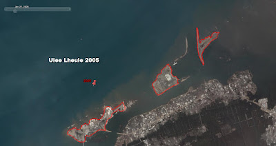 This is the same location, the island Ulee Lheule, but from the 2005 aerial. This was also digitized with a pen. Notice that there are three obvious sub-islands. You will need to create a separate polygon for each island. Create a folder to place your sub-polygons into and then do your adding of polygons.
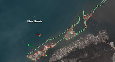 Finally, here are both layers from 2004 and 2005 on one image. Clearly there's some erosion that's taken place and/or inundation of ocean water on Ulee Lheule.
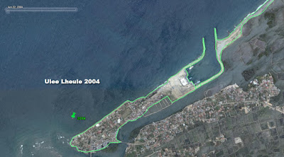
Above is the outline of a barrier island, Ulee Lheule, from the 2004 aerial. If you click on the image you can see it much bigger and better. This digitized line was done with a pen and the larger image will show you the smoothness of the line. I smoothed the link even more with some further zoomed-in editing. It was easy to do.
This is the same location, the island Ulee Lheule, but from the 2005 aerial. This was also digitized with a pen. Notice that there are three obvious sub-islands. You will need to create a separate polygon for each island. Create a folder to place your sub-polygons into and then do your adding of polygons.Finally, here are both layers from 2004 and 2005 on one image. Clearly there's some erosion that's taken place and/or inundation of ocean water on Ulee Lheule.Now, to quantify the area and volume of land lost in one year will be the next step. Visually, it is obvious. My next step will be to try to measure the area of Ulee Lheule both in 2004 and 2005. In Google Earth, we can measure distance, but in ArcMap, we can measure area and volume.


1 comment:
Wow! beautiful digitized pictures.Really thankful for sharing tips of operation on tablet PC.
Regards
GIS data conversion
Post a Comment