
The other kudo is the newly revamped Environmental Studies program's web page that features "Field opportunities" and show ME helping out a student using a tablet PC. This shot was taken on the same day as the one above. Another nice mention under 'Campus facilities' is that we have a "GIS laboratory," though they used this blog's link and not the GIS lab's own, out-dated web page. Here I am...
Tuesday, December 23, 2008
Shout Out to Tablet PCs at Vassar


Monday, December 22, 2008
GIS in Higher Education Conference at Skidmore College

Skidmore College is hosting a GIS conference January 9, 2009, geared towards those of us in colleges and universities. These conferences that Skidmore has put on before are very effective for meeting other geospatial folks in higher education and hearing what your GIS colleagues are doing. I highly recommend this conference. Here is what Skidmore's Alex Chaucer says:
The Skidmore College GIS Center will be hosting a regional GIS conference at Skidmore College in Saratoga Springs, NY, on Friday, January 9th, 2009. We will be focusing on GIS in the college setting. Some possible topics for presentations/conversation include: GIS and statistics, supporting student and faculty GIS research, community GIS, and creative applications. We also are open to other topics, and if there is something that you think may be a good discussion topic, please let me know.
Please RSVP to Alex Chaucer, achaucer (at) skidmore.edu
Google Earth, Sanborn Maps and NYC in 3D

You don't need your own plane or helicopter to get remarkable views of New York City. Check out a great post at the Ogle Earth blog on the combined project of Google Earth and Sanborn maps integrated with accurate photography of lots and lots of New York's buildings. Stefan also has some really nice screen captures to highlight this interesting project. Just zoom into New York City in Google Earth to see these buildings (with Buildings layer turned on, of course). Rendering was pretty quick.
Monday, December 15, 2008
Landsat Data from the USGS

Landsat imagery data going back 35 years or more are available on the USGS web site. Read about the landsat program on the NASA site and find the data here on the USGS site. Enable Java and allow for pop-ups on this site. See below for a look at the data download window.

The USGS's EarthExplorer is another remote sensing and geospatial data download site worth checking out too.
Thanks VerySpatial .
Sunday, December 14, 2008
Creating Your Own Maps With Google MapMaker
 Adding to the democratization of map creation and wikification of mapped data, Google has made available Mapmaker. From the Google LatLong Blog: "Map Maker now allows people to create complete maps for 164 countries across the world. As we expand the launch of Map Maker to more countries, we never forget that for any user it's all about the world they live in." Above is the location of the best bake and shark in Trinidad.
Here's a how to get started in Map Maker page.
I think that this sort of map creation has been available through Google Earth, but there's still a slight disconnect for those folks who don't want nor know how to download the Google Earth geobrowser (like my in-laws). Making maps in a standard browser is now even easier.
Edited 12/22/08
So I tried out a post/placemark showing one of my most favorite places to eat, Richards at Maracas Beach in T&T. I placed the placemark and got back a response. Surprise! Someone is watching out for accuracy!
Action : Comment
Remarks : Hey, all that I could see there is water, are you sure about the location of this edit, if not please undo this.
signed, Google Map Maker
My bad. I tried again.
Action : Comment
Remarks : Hi, I am not able to locate the feature from the image.. Are you sure about the location???
signed, Google Map Maker
Wow! And I call myself a GIS guy. OK. So when I turned ON the satellite photos I was able to see that I was NOT in a place where there could be a yummy shark and bake shack because I was located in a forest. Again, my bad. I tried once more and, TA DA!, I think I got it right because the Google Map Maker didn't get back to me and here is the placemark (below). I do like knowing that there's some quality assurance/quality control to Google Maps, don't you?
Tuesday, December 02, 2008
NERCOMP Pen-based Technologies SIG
 Keri VanCamp and I gave a talk at the NERCOMP mini-conference as I discussed previously. There were four sets of speakers and all but we discussed pen-enabled technologies within a classroom setting. Our presentation, of course, focused on our use of tablet PC in 'outdoor' classrooms. Though this is a talk that I have given and modified from the first time I gave it (NERCOMP annual conference), each time something is added and I hope each time it improves.
I thought that this was one of the better NERCOMP SIGs that I've been too. The first speakers from WPI brought in a lot of pen technology tools and discussed where their focus is at this point. They plan to deploy Sympodiums by Smart to their technology-rich classrooms. I think that sounds like an ideal solution between a Smartboard and a tablet PC. Another interesting and notable point made is that we are seeing pen-technologies sold in places like Target and Circuit City...Wacom tablets and LiveScribe, to name but two. I believe we are starting to see the mainstreaming of pen technologies. Frankly, the more varied technologies we have to choose from not just as educators but as consumers the better for those of us with different learning styles and preferences.
Another issue that came up was the use of wireless with a tablet PC, especially in a classroom with many tablets. It can give troubles if your wireless is encrypted, but I'm not that versed on it. This is troublesome since we are investigating a wireless/projection tablet implementation.
Lastly, a point that came up is that there was a sense that tablet PCs have been slow to take off in higher education because of the heavy Macintosh use on our campuses. This is likely true. One attendee said his experience with the Axiotron was less than satisfactory. We don't have pen-enabled Macs now, it's been but a rumor for years, it probably will not happen that Macs will make the tablet PC of the higher educator's dreams.
By the way, no one gave a talk on Smartboard use. Not surprising but notable.
Friday, November 28, 2008
I'm A Tablet PC Video - What's Missing?
I haven't heard much of what went on at the WIPTE conference in October, but I did hear about this video. It's a take-off of the I'm a PC commercial. I'm posting about it because I'm fond of tablets, of course, but also, these folks missed one of the greatest reasons to have a tablet PC. They should redo this and and have some geologist in boots and sunglasses saying, "I'm a tablet PC and I'm collecting tsunami inundation measurements." Then they can add an ecologist in hip waders saying, "I'm a tablet PC and I'm mapping invasive species." Nobody asked me.
Thanks, GottaBeMobile.
Friday, November 21, 2008
Mapping Pirate Activity
 I rarely watch the news. I guess I've started back up again with the heartening news of the recent election. Anyway, I heard about all this 'pirate' activity in the area near Somalia involving the hijacking of big cargo and oil freighters. Sounds scary, right? And it is, but when looking at the ICC Comerical Crime Services web mapping of pirate action, you see that these high seas terrorists are all over the place.
Sunday, November 16, 2008
Short Videos Showing How To Do Functions in Geospatial Software
I recently started using TechSmith's Camtasia and hope to make some short, instructional videos showing how to do different functions in GIS and geospatial software. I'll put these videos on the GISatVassar YouTube site. And if anyone wants to see a particular function done as a video, let me know at mestewart (at) vassar (dot) com.
Wednesday, November 12, 2008
Google Earth and Ancient Rome
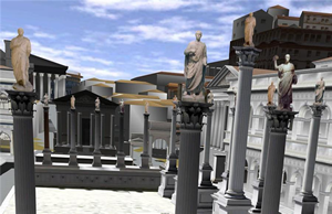 Now this is good. It took awhile to be made available but it is there now so I'm going to blog about it. Google Earth added an ancient Rome layer under the Gallery category. In it is a model of Rome circa 300 AD, which is really amazing. I learned about this Rome layer on the Google video.
Thankfully it is in easy-to-use Google Earth and not in something like Second Life. There are plenty of educational opportunities with this layer and I am sure there will be more clever layers to follow. The matchup of Google Earth with SketchUp is a great combination for educational purposes. This application of using historical data with real terrain is perfect for Google Earth and the kind of thing that people try to re-create in Second Life where it just seems forced. But I've never been a Second Life fan and now I wonder when Google will come up with Roman warrior avatars driving chariots around Circus Maximus. Now THAT would be educational!
 I heard about this new Rome layer early this morning and thought that, to view the new layer, I must download Google Earth again. I don't think that is the case. My Update Google Earth function said that I had the latest version, but I did not see the Ancient Rome layer. It just took longer than I expected to see it in my Layers list (circles in green below).
 Thanks, psychemedia and Google LatLong blog and Ogle Earth blog, where you'll get a lot of background information on how this project came into existence.
Monday, November 10, 2008
NERCOMP: Pen-based Technologies for Teaching and Learning
 If you're in the area of the northeastern part of the United States and interested in pen-based teaching technologies, check out the December 2 NERCOMP (Northeast Regional Computing Program) special topic session "Pen-based Technologies for Teaching and Learning." I'm co-presenting with Keri VanCamp on "Enhancing Field-based Classes Through the Use of Tablet PCs for Pen-based Data Collection" at 10:10 am. Looks like all the other presenters are talking about keeping the tablets INSIDE the classroom. Lunch included.


